|
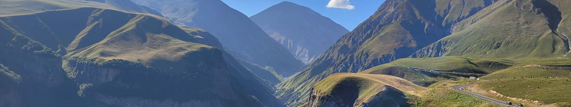
Georgian military road Georgian Military Road, known also as Georgian military highway is the historical name of the road that connects the capital of Georgia - Tbilisi - with the capital of North Ossetia across the Greater Caucasus. The total length of the road is 208 kilometres, the highest point is the Cross Pass with an altitude of 2,395 metres above sea level. Route of the Military Road The Georgian Military Road starts from the northern exit of the capital Tbilisi, goes along the right bank of the Kura River and after about 3 kilometres the road enters the Aragvi Valley, passes through the villages of Passanauri, Mleta and over the Cross Pass down to the village of Kobi, where the Aragvi Valley meets the Truso Valley and continues through Stepantsminda and Daryali Gorge to the capital of North Ossetia - Vladikavkaz. The Georgian Military Road is part of the 1,120-kilometre European route E 117. History of Georgian Military Road Since the Bronze Age, there has been a route connecting the North and South Caucasus via Georgia, through the Aragvi and Terek valleys. The route was often called the Dariali Way because of the Dariali Gorge. The name Georgian Military Road was given to the road in the XVIII century. It was used by the Russian army to invade Georgia, but also during the Russo-Turkish wars to move troops south as quickly as possible. People of the South and North Caucasus maintained close cultural and trade relations mainly via the Military Road. The Scythians in the VI century BC travelled mainly south and south-east along this route. The Greek historian Strabo in the 1st century B.C. and the Roman geographer Pliny in the 1st century A.D. described the route as one of the most beautiful, but also very dangerous due to falling rocks, narrow paths, sudden fog and, above all, frequent robberies. The importance of the road was so great that the great powers always tried to control it. In the first century the road was under Georgian and Roman troops. After the Arab invasions in the VII century, the Arabs controlled the road and secured the crossing from north to south against the Alans. After the devastations of Temur Leng (XIV century), the road lost its interest, which is why the first embassies from Russia in the XVI century used another route to reach Georgia (via Tusheti to the Kakheti region). It is possible that the raiders and the mountain people, who had a very negative attitude towards Russia, forced the neighbours from the north to look for alternative routes to the south. From the 18th century, during the Russo-Turkish wars, Russia began to widen the road and build several defence posts. It was only in 1769 that the Baltic-German general in the Russian army, Eduard von Totleben, managed to move Russian troops of about 5,000 men south along the Georgian Military Road. Providing security along the Military Road was not only unpleasant for some self-proclaimed Georgian princes, but also for Chechens, who used the road to transport abducted children and women from Georgia to the north, where they were sold at various human bazaars. The road was only finally secured in 1783, when Georgia signed a peace and aid treaty with Russia - the Treaty of Georgievsk. The treaty allowed the Russian army to establish military bases in Georgia and to move freely. In the course of time, the course of the military road was changed several times, and as it looks in the 21st century, after 30 years of arduous work, it was completed in 1863. By that time, Georgia had long been part of the Russian Empire. Significance of the Georgian Military Road during the Soviet era 1922- 1991 During the Soviet era, a railway line was built between Georgia and Russia via the region of Abkhazia and most of the traffic was transferred to rails. In 1985, an almost 4-kilometre-long road tunnel called the Roki Tunnel was built through the Greater Caucasus in the Samakhablo region (South Ossetia) at an altitude of 2,100 metres. The development of the tunnel and the construction of a railway line meant that the military road lost much of its economic significance. Importance of the Georgian Military Road after independence After Georgia's independence in 1991, a war broke out in the Abkhazia region, which led to the closure of the railway line and the road across Abkhazia. In 1994, an armed conflict also broke out in the Samakhablo region (South Ossetia), restricting traffic through the Roki Tunnel, and after the Georgian-Russian war in 2008 it was closed completely. For these reasons, traffic between the South and North Caucasus was once again transferred to the Military Road and the historic road has regained its economic importance Georgian Military Road today The only official link between Russia and Georgia today is the Georgian Military Highway. All cars and lorries travelling to Russia from the neighbouring countries of Azerbaijan, Armenia, Turkey, Iran and so on have to use the Georgian Military Highway, which is why you see many cars with different country plates on the road. An important gas pipeline from Russia through Georgia to Armenia also runs along the road. Things to see along the Georgian Military Highway Many poets, such as Pushkin and Lermontov, wrote about the beauty of nature in their poems, as did the French writer Alexander Dumas in his famous novel "Journey through the Wild Caucasus". The most photographed sights, such as the Ananuri Fortress and Church, the Georgian-Russian Friendship Monument and especially the Trinity Church of Gergeti at the foot of Mount Kazbek, are also located along the Georgian Military Road. It is very easy to organise a day trip to Stepantsminda from Tbilisi through various English-speaking travel agencies and admire this unique landscape in the middle of the Greater Caucasus with your own eyes. On following trip, you will visit Georgian military road |